Monday, 17 September 2012

Festival of the Plow

The Festival of the Plow was held in the neighboring village of Low Burnham.  It truly celebrated the plow.  There were horses plowing, steam plows, tractors, rototillers and anything else you can think of that could plow was demonstrated.  Terrier raced as well as ferrets. Birds of prey were on display and it could arrange to have them come fly over your fields to catch rabbits. Tents of vendors selling a wide variety as well as tents of poultry, antique farm equipment, models of fairs, boats and steam engines were set up.  Dancers, bands, a carousel, kiddy carnival rides, and food booths rounded out the assortment.

John was amazed by a pair of steam tractors pulling a plow between them by means of a steel cable.  This method was used into the 1960’s.
First tractor- up hill pulling plow
 
second steam tractor-down hill- pulling plow
 
 
pulled plow-double sided doesn't turn around, other side just engages
cable to pull plow


I like the horse plowing competition.  The competition seemed to be who could plow the straightest and most even rows.

 
                         The ferret racing was fun to watch though none of them were very fast.
Ferret race couse
 We haven’t seen many birds of prey flying around England. Talking with the people who had them on display, we learned that many of the birds of prey were killed so they wouldn’t hunt the pheasants as people like to do that.  The ones they had were hand raised and trained to only hunt rabbits, so they could help farmers. No mention of birds hunting mice. To see wild birds you need to be in forested areas away from large estates where hunting was or is popular.

Thursday, 13 September 2012

Choral Society

I've joined a Choral Society. It meets once a week to practice and gives 3 concerts a year. We are currently practicing for the Christmas concert. No carols song here so far. The music is varied from something by Handel ( not the Alleluia chorus) to a new composition by Karl Jenkins all in 4 part harmony. Think the One More Time Around Band in voice form.

Monday, 10 September 2012


Chester

This is a town from Roman times. It lies on the western side of the country south of the Mercy River from Liverpool.  It has the Roman wall, remnants of a Roman amphitheater, and a historic city center dating from medieval times. It’s a smaller version of York.
City center, Roman wall, clock tower
 
Shops in city center
 
Equinox parade

 
We were there just after the spring equinox and caught the parade through town celebrating that event.   
Roman wall and gate. On left pillars in Roman garden
 
Roman Amphitheater- St John's church in trees
         
  The church of St, John, near the amphitheater, couldn't maintain the east end of the church, so they built a new east wall and let the end of the church fall to ruin. As it did, so they discovered a coffin with a body had been built into an arch way.  They don't know who it was or why.  Just the coffin remains now.


Coffin built into arch of church.
East end of church- coffin in left set of pillars.


Sunday, 9 September 2012


Clumber Park


Main Entrance


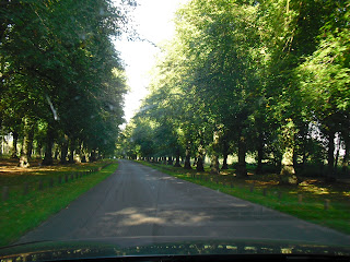
Trees lining the entrance


This is a property owned and developed by the Dukes of Newcastle.  The line ended about the time of the Second World War and the National Trust became the owners. It is in part of Sherwood Forrest.  
Sherwood Forest
 
 It has 3,800 acres with a chapel, walled kitchen garden, lake, and woodlands. The main mansion burned and only the foundation outline exists. 
Side view of Chapel
Center aisle of chapel
Walled kitchen garden.
Designed to keep in the heat allowing a wider variety of plants to be grown and a longer growing year.
 
Lake and swans


There are 20 miles of cycling paths and a cycle hire. We rented bicycles and toured the paths around the lake, 5 miles, as well as one of the border trails through the forest another 5 miles before having to return the rentals. 
View of Chapel from bike path across lake.

 
Bridge from South entrance over lake
 Because it is such a large park, there is a cricket field, camping areas, picnicking and people everywhere enjoying an unusual 80 degree day in England.


Lake District

We spent the weekend in the Lake District national park in the village of Keswick on Lake Derwentwater.  We stayed in the Badger Wood Bed and Breakfast because it catered to special diets. The breakfasts were wonderful and filling.

The highest mountains in the area were around 3500 ft.  Which is much higher than we were told was England’s highest peak.  It was a busy market town on Saturday with a lot of tourists as it was the last weekend before school starts again.  There is a small local theater that shows a different play every night so we went to both the Friday and Saturday plays.
Walla Crag destination of our hike.

Since walking (hiking) is the English past time we, after talking with our host, set out on a medium difficult 4 mile hike. We started by taking the lake taxi counterclockwise around to the 6th stop. The taxi goes a different direction each half hour and takes an hour to circumnavigate the lake.
 
Taxi boat at dock
 
 Our goal was to get off at Ashness Gate Pier, walk to Ashness Bridge, take a trail from there and hike around Walla Crag, down Cat Ghyl trail and back to Keswick.

Ashness Bridge
We got off at Ashness Gate pier and proceeded uphill toward Ashness Bridge. Since this bridge is the most photographed bridge in the Lake District, we were expecting something outstanding or breathtaking.  We hiked to a stream with a small bridge crossing it and assuming this was not the bridge hiked on. 
 After two miles up hill and reaching a sign announcing the summit of the road and no bridge insight, we wondered where to go. John hiked about a half mile ahead while I enjoyed the woods from the summit of the road.
Forest from road summit
 
 
He didn’t see any sign of a bridge and as we were hiking away from Walla Crag we decided to forget the bridge and return to hike around the crag.

On the way back we did stop to enjoy a viewpoint looking out over the lake. Asking some of the people there where the bridge was, and where we were, we got answers of “they didn’t know” to “we passed the bridge about a mile and a half back.” It was the small bridge we had crossed.  We hiked back to that bridge and asking again where the trail was to Walla Crag?  Our guide book kept telling us to go through a gate to the bridge then retrace our step to the gate return through it and turn up hill.  We had never seen any gates to go through.  We were shown the trail that cannot be seen as you approach from downhill. 

We started up hill and the track wasn’t bad for a while then it became a sometimes dry waterfall, sometimes wet, often muddy, big steps even for my long legs, and very steep in parts.
View of trail, fern field, bridge in background
Trail with Stream
 After the first section it wasn’t as steep but the water and mud stayed.  I did notice people taking a more gradual path down. I wish we had found that for coming up.

The view was great and as we got to the top of the ridge the sun came out.  The wind was blowing so it didn’t get hot.  The higher hills were covered with ferns and blooming heather.  Above us was Falcon Crag with birds soaring around it. Of course all around us were sheep.
Falcon Crag heather in bloom
The trails were determined by where others had walked or where water had washed away the top soil.  The ground was covered by soil, duff, moss, heather and ferns.  Water ran out of the ground from under this top mat and down the path or in streams down the hill. We assumed the water would be crystal clear, but it was brown in the pools where it gathered probably from the rotting matter, marsh or bog, through which it flowed.
Water running from under peat
 
We hiked the ridge and then wandered through the marsh land behind the crag.  We followed the trodden path down the north east side, by two camp grounds and back into the city.  The path down the hill was steep and grass covered. 
Looking up hill we walked down


Path we still had to walk down


Had it been wet we would have slid down the hill.  If you have ever skied at Bachelor it was like walking down Thunderbird.  We never saw the route that went directly back to the city, so at this end we probably added another 2 to 3 miles to the walk.

                                       Just outside Keswick is a neolithic stone circle, Castlerigg. 

Sunday we drove south through the middle of the Lake District and took a small road home.

Bolton Castle was on the way and we toured this example of a medieval fortress.
Bolton Castle
It was completed in 1399. This castle was very modern for its day. It had guard robes (bathrooms) for every bedroom, major hall, guard barrack, and for guards at duty stations.  These included areas it wash your hands.

Guard Robe
Wash basin of Guard Robe

Because it was so well designed and included everything needed for daily life it survived an attack for 6 months during the civil war in 1636 even when it was partially destroyed.
Solar - South facing day room


The family left in 1675, but allowed people in the area to make their homes in what was left.  In 1999 the family did extensive work to make the castle safe and accessible for visitors.  
Mary Queen of Scotts bedchamber when she was being held here.